Based on the presentation “Groundwater-Surface-Water Interactions in Grand Canyon National Park” by Gus Tolley
Henry Philibert Gaspard Darcy was a Frenchman employed by the Corps of Bridges and Roads in Paris, France in the early 19th century. Darcy revolutionized municipal water systems when he installed a pressurized water distribution system in Dijon, replacing failed wells. One of his key mathematical insights that allowed to Darcy to pull this off is a formula of flow through a porous medium. Darcy derived his formula by observing water flowing sand, the result can be obtained through the use of first principles as well.
Darcy’s Law: Q=-A*K dh/dl
Q = flow rate, A = cross sectional area of flow, K = hydraulic conductivity of porous medium, dh/dl = the energy gradient
Darcy’s formula binds some fairly straightforward properties of flowing fluids. Water flows from areas of high energy to areas of low energy. The longer the distance over which the difference in energy is expressed, the more slowly it flows. Water flows faster through more conductive media. This formula is known as Darcy’s Law, and nearly two hundred years later is helping hydrologists understand how distant groundwater pumping affects surface water flow in the Grand Canyon.
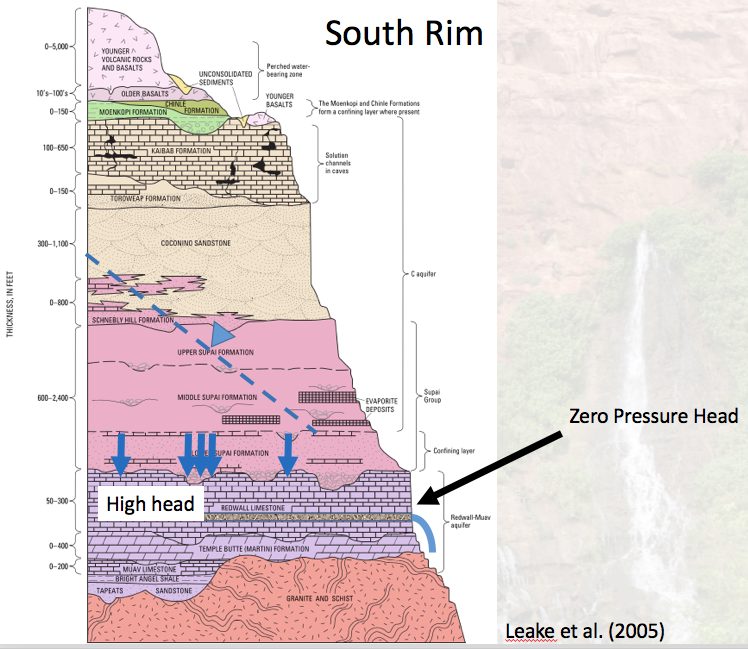
The C-aquifer is the largest and most productive aquifer in the Grand Canyon area. The aquifer takes its name from its primary water-bearing geologic unit, the Coconino Sandstone, but it also includes the Kaibab, Upper Supai and Middle Supai formations in the South Rim area near the canyon. Most of the recharge to the aquifer occurs in areas where surface outcrops of the aquifer coincide with high precipitation rates. In other words, the areas where the C-aquifer units have been “day lighted” or exposed due to erosion of the overtopping units also tend to receive a high amount of precipitation, relative to the surrounding areas. Precipitation flows directly into the units where they are daylighting, or flows down through overtopping units in a process known “vertical infiltration”, running down through volcanic dykes to the Coconino Sandstone. This recharge happens along the Mogollon Rim and on the Defiance Uplift, with the water entering the aquifer flowing towards the Colorado River to the north and the Little Colorado to the northeast. The aquifer never fills all the way up because the Grand Canyon is so low.
In most watersheds, groundwater is below the stream, but because the Grand Canyon is so incised, this arrangement has been reversed. In most watersheds, interactions between groundwater and surface-water happen in both directions: with surface water at times recharging the aquifers, and the aquifers feeding the streams, with the direction of interaction changing seasonally and spatially. The Grand Canyon is so deep that interaction is one-way, with ground water affecting surface water only.
As water that enters the aquifer via the exposed Coconino and Kaibab formations to the south makes its way toward the canyon, the hydraulic gradient is also forcing it down through the Supai formations. The water is able to even infiltrate into the Rewall-Muav (R-M) aquifer, bypassing the confining layer via vertical fractures. Water within the R-M aquifer has some amount of energy due to increased pressure. Where the aquifer is exposed in the canyon, a lower energy boundary condition results in an energy difference and therefore a hydraulic gradient.This causes water to flow out from the aquifer and into the canyon. Blue Spring, the largest spring originating from the R-M aquifer, can flow up to of 48,000 cubic feet per second (cfs).
When water is obtained from wells, its via one of three processes:
1) Increased recharge to the aquifer
2) decrease discharge from the aquifer
3) change in aquifer storage
In general, groundwater pumping results in decreased stream/spring flow at some location at some point in time. While the effects of pumping on stream flow in the canyon actually are small due to flow regulation from Glen Canyon Dam, ground water pumping around the canyon can reduce the hydraulic gradient of the water all the way down into the R-M group, diminishing the flow of water out into the canyon. These spring flow depletion effects are of much greater concern because while springs are only 0.01% of Grand Canyon landscape, species concentrations are 500x greater at springs than surrounding areas.