Geomorphic Distribution

Site 2 is located just outside of Swinging Bridge Canyon in Lower Brown’s Park. Lower Brown’s Park is classified as a restricted meander; the river can meander into soft alluvium deposits until restricted by bedrock. The river here is restricted at river right by Precambrian quartzite of the Uinta Mountain Group. An island and backwater habitat along river right has been created here by sediment deposition and slow moving water. The habitat map of the Lower Brown’s Park sandbar graphically demonstrates the geomorphic surfaces of this locality. The floodplain is inundated annually during high flows and is mostly fine silt with some gravel- sized deposits on the upstream side of the island. Marsh vegetation such as typha grows on this surface of the island. Sand is deposited on the intermediate bench in the center of the island during higher flow events occurring approximately every 5 years since Flaming Gorge Dam was completed. Tamarisk is the dominant vegetation type on this surface although some coyote willow is also present. Above the cutbank on river right is the pre-dam floodplain that has not been inundated since before Flaming Gorge Dam was completed.


Riparian Vegetation
Riparian vegetation of Lower Brown’s Park Island was diversified in the lateral and longitudinal direction. One transect was laid laterally spanning between the waters edge on the north side to the south side (see geomorphic map). The post-dam active floodplain was solely colonized by marsh vegetation (Fig.1). Moving inland, and approaching the intermediate bench, riparian vegetation populations became a mixture of coyote willow, tamarisk and marsh vegetation. Tamarisk and willow appeared to be of similar age classes and all appeared to be of one or two age classes. With increased progression along the transect toward the opposite water edge, coyote willow became more abundant than tamarisk. Most of the coyote willow sampled along the transect appeared to be cut by beaver. Once reaching the opposing post-dam floodplain however, tamarisk and coyote willow were no longer sampled there and only marsh vegetation was observed (see geomorphology cross-section).

Though the longitudinal trends of the island were not sampled, we also observed a change in vegetation longitudinally. The most upstream portion of the island was void of any vegetation. Moving inland from the upstream water edge, tamarisk was the only vegetation observed. Here the soil was gravel. Moving downstream we observed a transition into a strongly mixed population of coyote willow and tamarisk. This dense population was observed on the intermediate bench where the soil primarily appeared to be sandy. Further in the downstream direction it appeared that elevation declined and the geomorphic surface again became a post-dam terrace. Primarily marsh vegetation was observed in this area and the soil appeared to be fine grained.
Water Quality
The two backwater areas at this site were seined before measurements were taken. Therefore, turbidity values may be higher in these areas than when undisturbed. The backwater had virtually no water movement, which resulted in a lower turbidity due to quicker settling of sediments. The stagnant backwater had a slightly higher temperature, and a higher pH (perhaps due to increased plant photosynthesis).


Fish
Seine Collection Data:

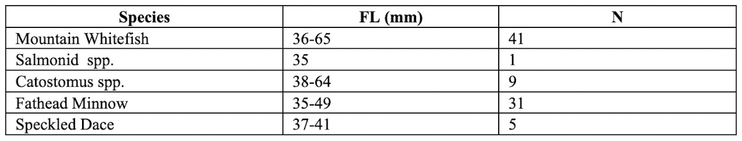
General Comments: Salmonids continued to dominate this section of the river, as angling efforts continued to produce adult brown and rainbow trout. From our visual observation the overall abundance of these fish seemed to decrease as we got farther from the dam. Several mountain whitefish were caught later in the day including a hefty individual who stretched our tape measure to 453mm and was a succulent addition to our supper. Seining occurred during daylight hours.
Aquatic Invertebrates
Only one site, a backwater vegetation bed, was sampled in this location. The substrate in the main channel was sand and no riffles were present.

Comments: Several large dragonfly larvae of the family Aeshnidae were found in main channel seines pulled by the fish research group.
BIRDS, MAMMALS, REPTILES, AND AMPHIBIANS
We surveyed this site for an hour in mid-morning during a slight breeze and less than 25% cloud cover. The habitat at this site is composed of tamarisk, willow, scirpus, and typha. Birds were identified by visual sightings or track and scat recognition. There were no reptiles found at this location. Amphibians were identified by hand capture. Mammals were identified by visual sightings or track recognition. The animal assemblage of this site was restricted to species that could cross the river channel or get into the backwater habitat. As a result, our survey was mainly limited to the observation of tracks. The mud on the island’s edge allowed for easy track identification, such as that of the beaver (Fig. 1). The marshy vegetation provided suitable habitat for the Canadian geese, whose presence was documented in the form of tracks and scat. Asides from tracks, we also observed a great blue heron and a dead muskrat (Fig. 2).


