One of the most popular ways to experience the Grand Canyon is by rafting along the Colorado River, an activity that is enjoyed by over 20,000 people and that contributes more than $20 million to the local economy each year. A primary attraction for rafters is the series of >150 named rapids along the length of the Colorado River. While navigating rapids is an important part of the rafting experience for visitors to the Grand Canyon, evidence suggests that rapids have become more numerous and prominent in the last 100 years, in some cases threatening to leave portions of the Grand Canyon unnavigable for recreation. This policy brief discusses the process by which rapids are generated within the Grand Canyon, why rapids are becoming more prominent, what risks this poses for recreation, and possible solutions.
What creates rapids?
For mature rivers that have followed the same course for millions of years, the loss of elevation along the length of the river is typically gradual. However, the elevational profile of the Colorado is instead characterized by a “stairstep” pattern, whereby 66% of the vertical drop along the river is contained within just 9% of its length. This entails long reaches of fairly flat and calm water, punctuated by steep drops in the form of river rapids.
Rapids along the Colorado River typically occur where smaller tributaries connect to the main stem of the Colorado. These tributaries generally have very low flow rates, although summer thunderstorms can lead to dramatic spikes in flows.
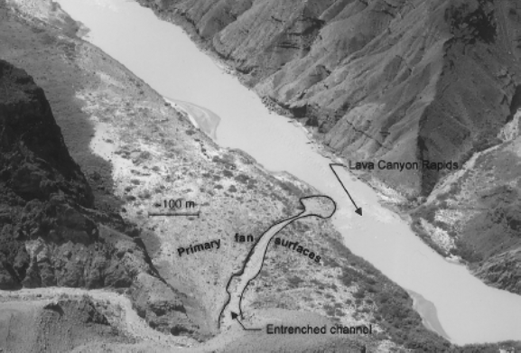
Thunderstorms that produce high rainfall rates on sparsely vegetated upland terrain can generate debris flows containing high volumes of fine-textured soils. The unique physical properties of these debris flows enable them to transport not only typical river sediments—clay, silt, sand, and gravel—but also boulders as large as cars. Where these tributaries meet the Colorado River, sediments and boulders create “debris fans” within the main channel, often constricting channel width by more than 50% (Figure 1). This constriction of the river leads to higher flow rates in the remaining river channel, which accelerates scouring of the underlying riverbed and thereby creates river rapids. Over the past century, as many as five new rapids per year have formed along the Colorado River.
Why have rapids become more difficult to navigate?
By comparing on-river surveys conducted in 1923 to modern data collected using remote sensing, scientists have estimated that the height of existing rapids along the river has increased by an average of nearly
0.25m, and the proportion of the vertical drop in the river contained within rapids has also increased. The increased accumulation of rapid-forming deposits in the Colorado River is likely a consequence of modified flow patterns associated with dam construction. Under natural pre-dam flow regimes, high springtime flows averaging 2,500- 5,000m3/s (and sometimes reaching 14,000m3/s) on the Colorado would erode existing rapids and widen the river channel in constricted areas created by debris flows; depositional processes associated with debris flows from tributaries and erosional processes associated with high mainstem flows were more or less at equilibrium. Dam construction greatly reduced the volume of water contained within peak river flows, such that peak springtime flows are now typically less than 1,000m3/s. This reduction in peak mainstem flows has contributed to certain rapids becoming increasingly difficult to traverse for rafters. For example, the Crystal Rapid, formed in 1966 by a debris flow that constricted the main river channel by over 80%, had become nearly impossible to navigate by the early 1980s, and only became safely passable after floods in 1983 and a controlled dam release in 1996 that reworked the channel.
What can be done?
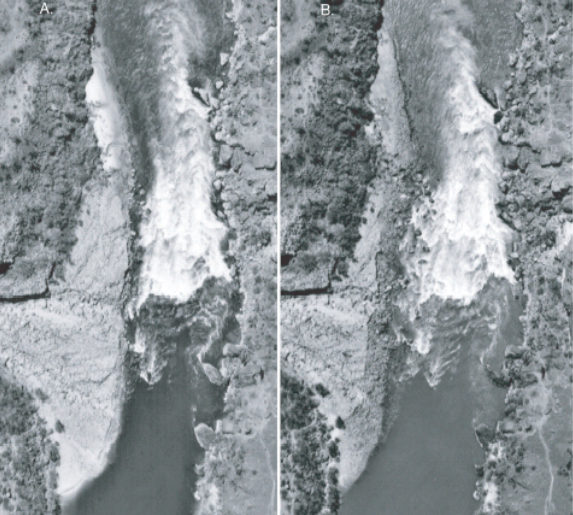
Periodical water releases from the Glen Canyon Dam designed to mimic natural flow regimes can help to maintain the hydrological processes necessary for river rapid evolution. Although dam releases are typically limited to <900m3/s for the purposes of maintaining hydropower generation, even single pulsed high flows may be enough to dislodge large rocks and boulders deposited in debris fans. This was the case in 1996, when a controlled high flow release of approximately 1,300m3/s from the Glen Canyon Dam helped to widen the river channel along several rapids, including Crystal Rapid and the Lava Falls rapid (Figure 2). Even though this controlled release was successful in limiting debris fan encroachment in some locations along the mainstem of the river, some scientists have suggested that flows as high as 2,800m3/s may be required to scour certain debris fans. In addition to channel widening, high river flow events can also improve recreational opportunities by limiting encroachment of vegetation on sandbars that are popular as campsites for rafters.
Further Reading
Collier, M.P., Webb, R.H., & Andrews, E.D. (1997). Experimental flooding in Grand Canyon. Scientific American 276 (1), 82–89.