Throughout a journey down the Grand Canyon there is an abundance of rock and clastic deposits easily observed close to the river or adjoining tributaries. The differences observed between these rock deposits are fairly simple to distinguish with a little instruction. Consider Figure 1.
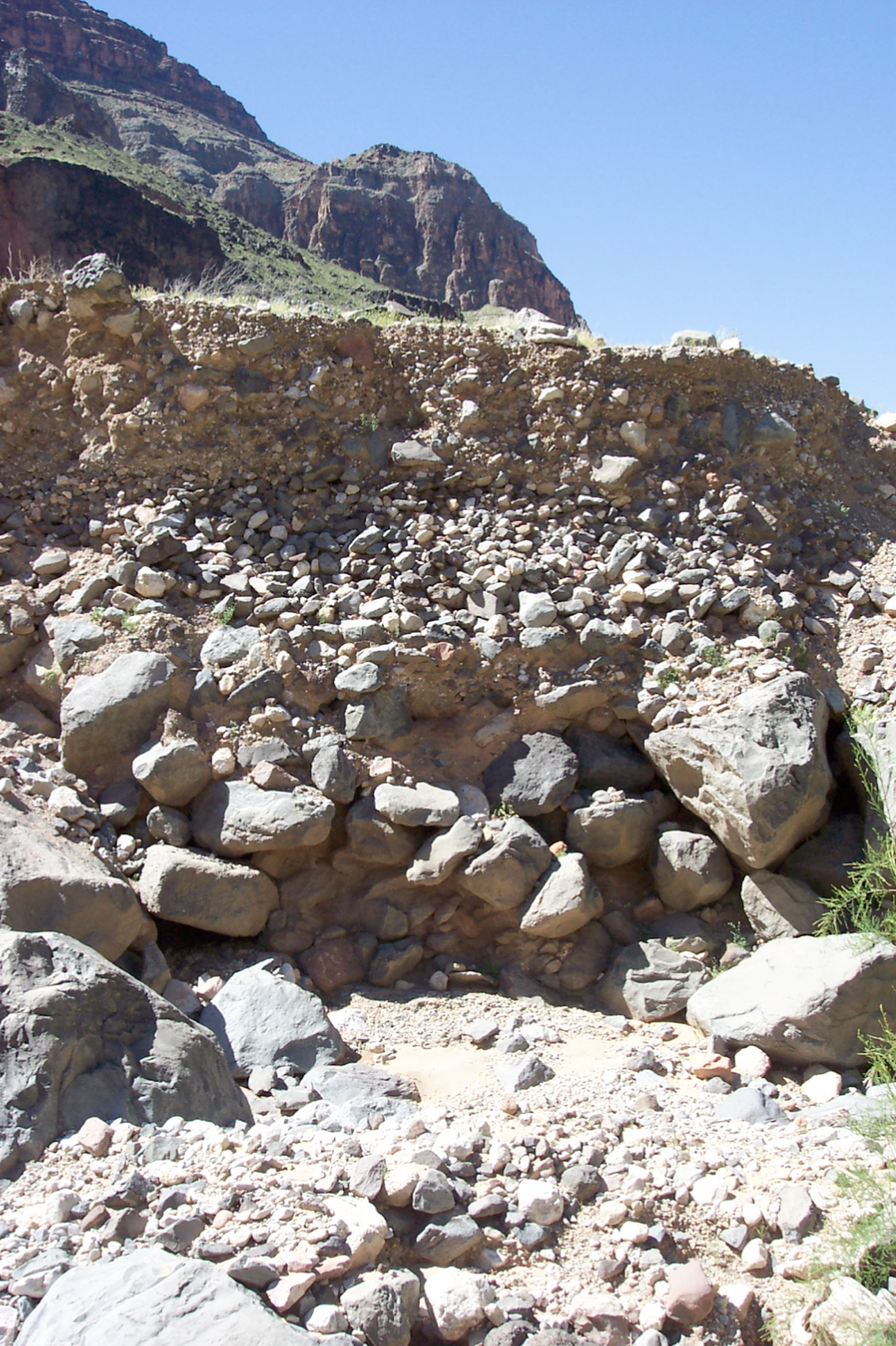
Figure 1. An outcrop near Lava Falls, three distinct bedding layers are visible. (Photo E. Buer)
There is a clear sequence of three primary beds which can be observed from the top of this deposit to the bottom. The first deposit is filled with rocks of all sizes, from very small silt particles up through cobbles the size of a basketball. This is a debris flow deposit. Debris flows are initiated during periods of lengthy or intense precipitation. They involve a mixing of rock and silt material with water to produce a thick, highly viscous slurry capable of carrying clasts of almost any size at high speed down a tributary to the mainstem. The deposits that are left behind are poorly sorted and supported by the fine clay and silt matrix that made up the fluid which carried other particles to their current resting locations.
The second layer is a clear bed of medium sized cobbles with almost no matrix visible. This is known as clast-supported since each rock rests on other rocks rather than a supportive matrix. This type of bedding is formed after a debris flow deposit has been reworked by the river, in which the fines are winnowed out and larger clasts are left behind for higher flows. Alternatively it may be a secondary debris bar formed during a very high water event, and these medium sized clasts have been deposited downstream of a debris fan-eddy complex where the river was constricted and entrainment values were higher than in the unconstricted channel.
Finally at the bottom of this stratigraphic sequence there is a bed made up of very large boulders as well as smaller cobbles and some fines. This deposit may have come from an exceptionally large debris flow, perhaps a bedrock failure near the end of a long period of precipitation. Following the debris flow a swollen Colorado River reworked and removed almost all the fine and medium sized cobbles. Subsequent more moderate flows may have deposited some medium cobbles until a smaller debris flow inundated the existing deposit. Alternatively it may be a landslide deposit in which a hillside or cliff face fails catastrophically and a large dry mass of rock and some sediment tumble to its present location. These deposits are notably lacking in matrix, since bedrock breaks initially into fairly large particles. Out of the three deposits observed in this outcrop the bottom is the most difficult to classify, since either of these processes would yield similar looking results in outcrop.
These types of deposits can be found throughout the Grand Canyon as well as many side tributaries. In many cases prehistoric deposits have been lithified into rocks known as conglomerates. In these cases the deposits look virtually identical to the younger deposits shown here with the exception that the outcrop matrix has been changed into a hard granular cement by precipitation of quartz, calcite or other minerals forming a single rock.
Another common example of sediment deposits that one can easily see along the Colorado River of the Grand Canyon are the sandbars along the margins of the channels and within eddy currents. Sandbars are created when the Colorado River water, which has a large concentration of sand, slows down to a certain velocity. Once the velocity of this water reaches a certain threshold, the water loses its ability to transport the sand and it settles to the bottom where it is deposited. The river water can slow down to form sandbars in two major ways. First, a rock obstruction can jut out slightly into the flow and cause enough of a velocity reduction around the obstruction to create a channel-margin bar. Second, a large constriction in the flow, usually caused by a debris flow, can cause sandbars to form in the upstream backwater eddy and also in the downstream separation eddy. The term ‘separation’ refers to the flow separating from the main channel and spending time in the slower-moving eddy created by a widening of the river channel after the constriction (Booth, 2005). In this eddy, velocities are reduced and sand is deposited at the upstream and downstream ends of the eddy.
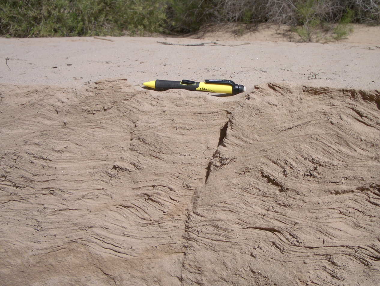
Figure 2. Ripple patterns in a recent flood deposit at river mile 139R. (Photo E. Booth)
Floods of the magnitude of the November 2004 controlled flood and above also create interesting ripple patterns in the sandbars. Figure 2 shows a cross section of these ripple patterns in a deposit from the November 2004 controlled flood. Ripples are a good way to distinguish a flood deposit from a deposit caused by wind at higher elevations on the sand bar. The action of wind transporting and depositing a sand particle is known as an aeolian process. Aeolian deposits will not contain ripple patterns but can be identified by large sand dunes as seen in Figure 3.
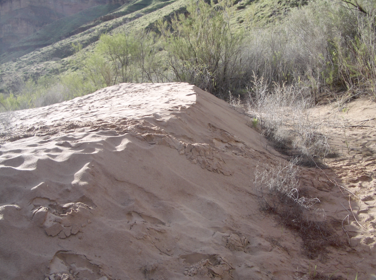
Figure 3. Large sand dune caused by aeolian processes. (Photo E. Booth)
LITERATURE CITED
Booth, E.G. 2005. "Sediment Response to Construction and Recent Adaptive Management of Glen Canyon Dam, Colorado River, Arizona." In. J. Mount, P. Moyle and C. Hammersmark (eds.). Ecogeomorphology of the Grand Canyon and its Tributary Streams. Davis, CA. http://watershed.ucdavis.edu/grand_canyon/history.html.