Fluvial terraces (a.k.a. abandoned floodplains) in a river system come in two basic flavors- strath and fill. Here's a quick primer on how the two form:
Fill terraces form when a large pulse of sediment enters the system (e.g. glaciers melt and saturate the river with sediment), and the amount of sediment is far greater than what the river is capable of moving. This causes the river channel to aggarade, or deposit sediment vertically essentially raising the level of the floodplain. This sediment fills the existing channel, and when the sediment pulse subsides the river has a new, elevated floodplain as compared to its previous floodplain.
Strath terraces form when the river channel incises laterally, as opposed to vertical incision or aggradation. This takes place when the amount of sediment is far less than what the river is capable of moving; the existing sediment in the channel acts as "tools" to move the channel from side to side. The floodplain formed by this lateral incision is the strath terrace.
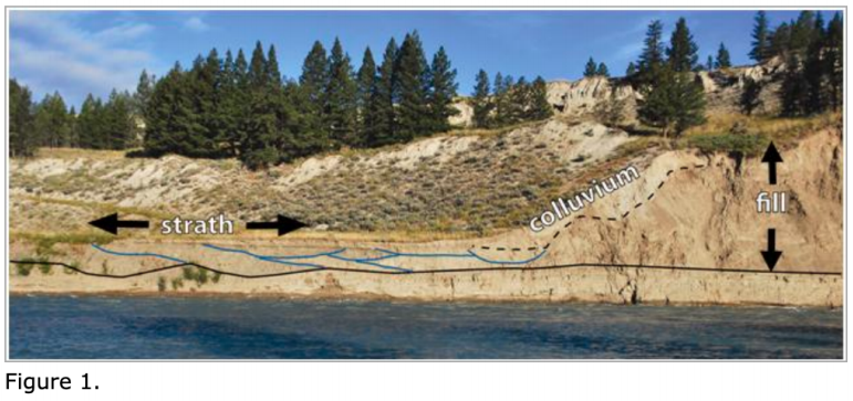
And, of course, here's an annotated photo of a fill and strath terrace on the Chilcotin River. The solid black line notes the top of laminated lake beds, which both these terraces formed above. The fill terrace formed first as the channel filled with sediment, elevating the floodplain. This period of aggradation was then followed by incision, where the channel first incised vertically (presumably to adjust to a new base level), and then laterally. Paleo-channels which migrated laterally are outlined in blue. Note that these paleochannels are not present in the fill terrace.