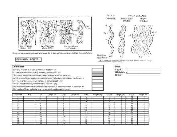
The study reach followed a progression along four braided rivers: Kennicott, Nizina, Chitina, and Copper, in their respective order. Along the progression the slope decreases by a factor of two and discharge significantly increases at each confluence. One of the objectives of the research trip was to study how changes in slope and discharge would influence the style and degree of braiding along the study reach. The original field plan designed to investigate braiding involved quantitative measurements of total channel sinuosity, number of braid bars, and length of braid bars (see attached data sheet for braiding, Figure1). However, due to size, scale, and high flows along the study reach the original field plan was only feasible at limited sample sites along the Nizina River. Thus, the mean number of active channels per transect (line perpendicular to flow direction) was the only braiding index possible to apply on a semi-regular basis along the study reach.
The Kennicott River was a single channel at the put in for the trip at the McCarthy bridge. About a quarter mile downstream of the bridge, the Kennicott split into multiple channels and remained braided to the confluence with the Nizina. The number of active channels on the Kennicott ranged from 2-4 and averaged 3. The Nizina maintained 3 active channels for about 2 miles below the confluence with the Kennicott and then widened into a system that ranged from 3-6 active channels. Approximately 10 miles below the confluence with the Kennicott, the Nizina entered into a gorge at the geologic contact of the Cretaceous Kennicott Formation (sedimentary unit) and the Permian Skolai Group (primarily metasedimentary unit). The Nizina maintained a meandering, single channel pattern throughout the gorge. Directly downstream of the gorge, the Nizina divided into 2 active channels until its confluence with the Chitina one mile downstream. Below the confluence with the Nizina, the Chitina divided into a 3 channel system. At trip mile 40, the Chitina’s valley width widened significantly. The number of active channels also increased to over 5, but due to the large valley width it was not possible to accurately count all of the channels. The Chitina remained wide with > 5 active channels until the Gilihana River. Below the Gilihana, the Chitina narrowed and the mean number of active channels ranged from 2-5 until the confluence with the Copper River.
After reaching the Copper River, the flow stage was high enough to submerge the majority of braid bars, thus making it very difficult to distinguish separate active channels. However, large braid bars and major flow divergences and convergences provided some insight into the number of primary (first-order) active channels (defined by Williams and Rust, 1969). Estimates of primary channels underestimate the total number of active channels as many smaller channel divisions were unidentified. Five miles below the confluence with the Chitina, the Copper River becomes a single channel as it enters into Wood Canyon. Below Wood Canyon, the number of major active channels appeared to remain in the range of 3-5 until the downstream end of the Tasnuna River Delta (river trip miles 118-183). Below the Tasnuna River the Copper flows along the Bremmer Peninsula, a large glacial outwash plain from the Bremmer Glacier composed primarily of very fine grained material. Along this stretch and up to Baird Canyon, the number of main active channels seemed to decrease, ranging from 1-3. Through Baird Canyon the Copper River was one main channel. After Baird Canyon the Copper flows into Miles Lake, which is about 10 miles across. Below Miles Lake, the Copper River was one main channel as it flows along the face of Childs Glacier. Downstream of Childs Glacier, the Copper River changes dramatically into a deltaic system. The Copper River Delta turns into an anastomosing system with many independent braches with multiple channels within each branch. Due to the immense size of the Copper River Delta no estimates were possible for neither number of primary channels nor number of anabranches.
Braid bars often develop into semi-stable features that can emerge as islands and promote vegetation establishment [refer to (Wooster 2002) in this volume for more detail]. Along the Copper River study reach, there was minimal vegetation observed growing on braid bars. No vegetation was established on braid bars along the Kennicott or Nizina Rivers; the first significant vegetation in channel vegetation was observed on the Chitina River about 5 miles downstream of the confluence with the Nizina. Bars supporting immature willow stands persisted for approximately 15 miles along the Chitina to about the Gilahina River. This stretch along the Chitina (study reach miles 45-61) was the only notable vegetation on braid bars until the lower, deltaic reaches of the Copper River below the Childs Glacier (mile 239). Significant vegetation, often coniferous, was established in channel on larger morphologic features such as moraines, tributary deltas, point bars, and large islands with bedrock basement. Due to the lack of vegetation, the braid bars along the study reach appear to be unstable, transitory features. The instability is believed to be a result of the consistent high flow events that occur annually with the summer glacial melt that effectively submerge and scour the majority of braid bars. The channel along the Chitina stretch with vegetated braid bars was particularly wide, and thus potentially minimized the scour effect of high flows.
Based on Ashmore’s (1991) flume experiments there are four sedimentary mechanisms possible for braid bar initiation: central bar deposition, transverse bar conversion, chute cutoff of solitary or alternating point bars, and dissection of multiple bars [refer to (Wooster 2002) in this volume for more detail]. Once braiding has been established, all of these mechanisms can occur simultaneously to promote further braiding. The depositional mechanisms (central bar and transverse bar conversion) were prevalent along the study reach. Central bar deposition seemed to dominate along the smaller Kennicott and Nizina Rivers. Braiding on the Chitina River appeared to be more influenced by large scale diverging and converging flow paths. New braid bars were observed establishing downstream of converging flow paths, analogous to the transverse bar conversion mechanism. The erosional chute cutoff and dissection of multiple bars mechanisms did not appear to be primary factors for new braid bar establishment. However, a couple examples of dissection of multiple bars were observed on the Copper River about 15 miles downstream of the confluence with the Chitina River. Multiple bar dissection is uncommon and typically is only found in rivers with very high width to depth ratios.
As outlined previously, due to the large volume and size of the rivers along the study reach minimal quantitative field data on the degree of braiding was collected. From a qualitative perspective, the number of active channels along the study reach prior to the confluence with the Copper River, appeared to be primarily controlled by valley width. Valley width referring to the total zone the current channel is able to access (active channel plus floodplain). In many cases the valley width was significantly constrained by massive historical, glacially influenced fluvial and lacustrine terraces. High valley widths appeared to correlate with a greater number of active channels. Where the valley walls narrowed or were constrained the number of active channels seemed to decrease. The stability of braid bars, based on the presence of vegetation, also appeared to be positively correlated with valley width. The number of active channels, at least the maximum, seemed to increase along the Kennicott, Nizina, to Chitina progression. Suggesting the increasing discharge had a greater impact than the decreasing slope on the number of active channels; although, grain size differences along the progression could also play a substantial role. High flows submerging the majority of braid bars on the Copper River prevented further analysis on the number of active channels past the Chitina and Copper River confluence.
REFERENCES
Ashmore, P.E. 1982. “How do gravel-bed rivers braid?” Canadian Journal of Earth Sciences 28: 326-341.
Williams, P.F. and Rust, B.R. 1969. “The sedimentology of a braided river.” Journal of Sedimentary Petrology 39: 649-679.