The Copper River flows through a diverse landscape with variable vegetation, rock type, and glacial coverage. Water drains over and through all of these environments, leaching ions, carrying sediment - integrating the chemistries of each sub-watershed. With each confluence the rivers incorporate the “chemical fingerprints” of their tributaries, reducing fine scale complexity, and creating chemical patterns in time and space. This short report will look at these patterns in water quality and address the driving forces behind them.
Longitudinal Analysis
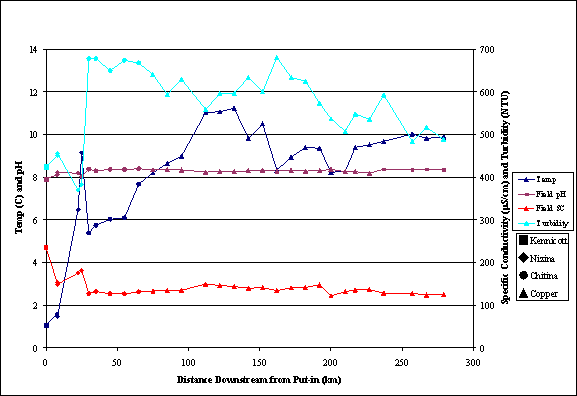
Putting in at the Kennicott Glacier and then proceeding downstream to join the Nizina, Chitina, and Copper Rivers provided us with the chance to collect a 280 mile chemical cross section of the waterways. Data was collect approximately every 5 miles along the main stem (Fig 1) and at every accessible tributary. The general trends are: 1. Turbidity increases with distance downstream, decreasing slightly between the Chitina and Copper Rivers, 2. Temperature, showing a general downstream increase, fluctuates with proximity to glacial inputs, 3. The pH declines slightly with distance downstream, 4. Conductivity decreases and then remains relatively steady for the last 250 miles of the trip.
To compare the chemistries of each major tributary it is convenient to use some simple statistics on the samples collected from each river (fig 2). Interestingly the Copper does not have the highest median turbidity, instead we find that the Chitina River carries the highest concentrations of sediment. This may be due to a number of factors including the reduction in stream gradient between the Chitina and Copper Rivers, the increase in the number and volume of clear water tributaries between the two rivers, and the relative percentage of upstream flow sourced from glacial melt. The Chitina River not only had the highest turbidity of all the rivers but also had the lowest median conductivity. Glacial outflow in this system was high in sediment and low in conductivity (see next section), thus it seems logical to conclude that among the rivers we floated the Chitina was the river most altered by glaciers, indeed if we analyze a map of glaciers in the area it can be seen that the Upper Chitina with its steep high elevation watershed has a vast number of glacial tributaries.
The high conductivity of the waters flowing from Kennicott Glacier (fig 2) was of special interest for waters flowing from glaciers generally carry little dissolved solids. Indeed, if we compare all the glacial tributaries we sampled to all the clearwater tributaries we can see that the median values for specific conductance are half that of the glacial streams (fig 3). Where then are the dissolved solids in the Kennicott coming from? There are
three possible answers to this question. The presence of the Kennicott Mine, with its associated tailing piles and mine drainage could, in theory, elevated the dissolved solids
|
River |
Statistic |
Turbidity |
Temp |
pH |
S.C. |
TDS |
D.O. |
D.O. |
|
Kennicott |
count |
10 |
10 |
10 |
10 |
10 |
10 |
10 |
|
|
median |
438 |
0.58 |
8.055 |
202.5 |
131.5 |
85.15 |
12.22 |
|
|
std dev |
18.4 |
0.4 |
0.1 |
24.3 |
15.7 |
6.2 |
0.9 |
|
|
max |
451 |
1.58 |
8.12 |
234.8 |
153 |
103.2 |
14.93 |
|
|
min |
425 |
0.35 |
7.75 |
153.1 |
100 |
84.1 |
12.03 |
|
|
|
|
|
|
|
|
|
|
|
Nizina |
count |
5 |
5 |
5 |
5 |
5 |
5 |
5 |
|
|
median |
393 |
6.48 |
8.19 |
175.2 |
114 |
101 |
12.42 |
|
|
std dev |
37.9 |
3.2 |
0.1 |
13.8 |
8.9 |
2.6 |
1.3 |
|
|
max |
456 |
9.48 |
8.22 |
183.2 |
119 |
104.6 |
14.23 |
|
|
min |
370 |
1.46 |
7.96 |
149 |
97 |
98.1 |
11.2 |
|
|
|
|
|
|
|
|
|
|
|
Chitina |
count |
9 |
9 |
9 |
9 |
9 |
9 |
9 |
|
|
median |
650 |
7.28 |
8.36 |
131 |
85 |
100.2 |
12.54 |
|
|
std dev |
27.6 |
1.3 |
0.1 |
7.1 |
4.6 |
5.7 |
0.7 |
|
|
max |
678.0 |
9.0 |
8.4 |
134.8 |
88.0 |
112.8 |
13.6 |
|
|
min |
594.0 |
5.4 |
8.2 |
112.0 |
73.0 |
96.6 |
11.2 |
|
|
|
|
|
|
|
|
|
|
|
Copper |
count |
17 |
17 |
17 |
17 |
17 |
17 |
17 |
|
|
median |
574 |
9.68 |
8.3 |
136.5 |
89 |
97.9 |
11.21 |
|
|
std dev |
55.8 |
0.9 |
0.1 |
8.6 |
5.6 |
2.9 |
0.3 |
|
|
max |
681.0 |
11.2 |
8.4 |
149.6 |
97.0 |
102.3 |
11.5 |
|
|
min |
484.0 |
8.2 |
8.2 |
122.0 |
79.0 |
89.7 |
10.1 |
in the water. The town of McCarthy, one mile above our put-in, could be discharging high conductivity waters into the Kennicott. Lastly, and most probably, the carbonate rich geology in the hills above Kennicott could have been contributing to elevated dissolved carbonates in the water, driving up conductivity readings. Elemental analysis on the samples will occur in the coming months; these data may elucidate this situation.
Along the length of our journey the general trend we witnessed was that the mainstem rivers became warmer, less turbid (exception Chitina), and more dilute. This would indicate that there is a change in the chemistry of the tributaries augmenting the mainstem flow. We will look at this in more detail ion the following section.
Tributary Chemistry
There were three type of tributaries identified during this trip, clear water, glacial water, and hyporheic water. The hyporheic tributaries formed on mid elevation bars, where the flood frequency was high enough to maintain the channels but no so high as to wipe them out entirely. The waters of these channels originated from a mixture of groundwater and subterranean through-gravel flow from the turbid main channel. Prior to passing though the gravels the main channel water tended to be cold, turbid, and dilute; after hyporheic flow and subsequent discharge into the side channels the water was warmer, clear, and saltier. Of all the tributaries measured the hyporheic channels had the lowest turbidity, highest temperatures, lowest dissolved oxygen, highest conductivity, and most abundant benthic flora. Where these channels joined the turbid channels is where the greatest abundance and diversity of juvenile fishes were found. With these data the picture which begins to form is of gravel bars acting as chemical filters, altering inhospitable, turbid main channel water and creating warm, clear, fertile water where fish rearing is ideal.
|
Tributary |
Statistic |
Turbidity |
Temp |
pH |
S.C. |
TDS |
D.O. |
D.O. |
|
Hyporheic |
Count |
13 |
13 |
13 |
13 |
13 |
13 |
13 |
|
|
Median |
0.35 |
9.83 |
7.9 |
313.1 |
204 |
89.3 |
10.16 |
|
|
std dev |
0.4 |
3.6 |
0.2 |
73.5 |
47.7 |
17.0 |
2.1 |
|
|
Max |
1.5 |
15.3 |
8.1 |
366.3 |
238.0 |
109.1 |
12.5 |
|
|
Min |
0.2 |
4.5 |
7.6 |
130.0 |
85.0 |
47.7 |
4.8 |
|
|
|
|
|
|
|
|
|
|
|
Glacial |
Count |
5 |
5 |
5 |
5 |
5 |
5 |
5 |
|
|
Median |
200 |
3.6 |
7.78 |
55.6 |
36 |
103.2 |
13.44 |
|
|
std dev |
174.2 |
2.5 |
0.2 |
73.0 |
47.4 |
2.2 |
1.1 |
|
|
Max |
425.0 |
6.2 |
8.1 |
206.2 |
134.0 |
104.2 |
14.9 |
|
|
Min |
16.8 |
0.4 |
7.6 |
27.2 |
18.0 |
99.1 |
12.7 |
|
|
|
|
|
|
|
|
|
|
|
Clear |
Count |
9 |
9 |
9 |
9 |
9 |
9 |
9 |
|
|
Median |
0.75 |
7.99 |
7.84 |
109.8 |
71 |
99.6 |
11.95 |
|
|
std dev |
2.8 |
1.0 |
0.4 |
88.0 |
57.2 |
4.2 |
0.5 |
|
|
Max |
8.6 |
8.4 |
8.1 |
294.1 |
191.0 |
108.8 |
12.9 |
|
|
Min |
0.2 |
5.7 |
6.9 |
30.7 |
20.0 |
94.7 |
11.1 |
Despite which lithologies were being drained, clear water tributaries had a higher median conductivity than glacial streams - most likely an indication that a larger percentage of the clear water channel’s flow is sourced from groundwater. It should be noted that these data are contrary to those found by Edwards et al (2000) in Denali Naional Park. They found that glacial tributaries draining sedimentary units had a higher conductivity than clear water tributaries draining the same units.
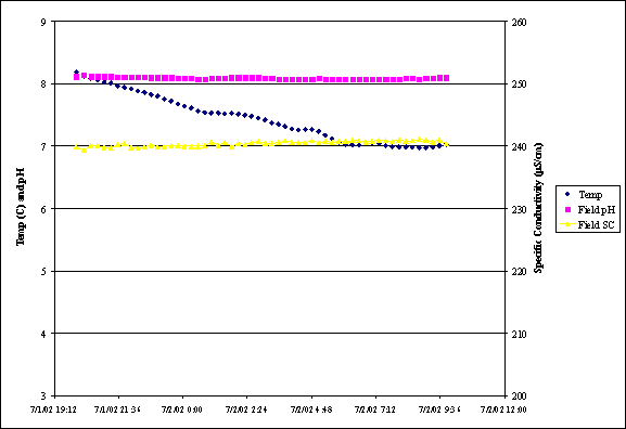
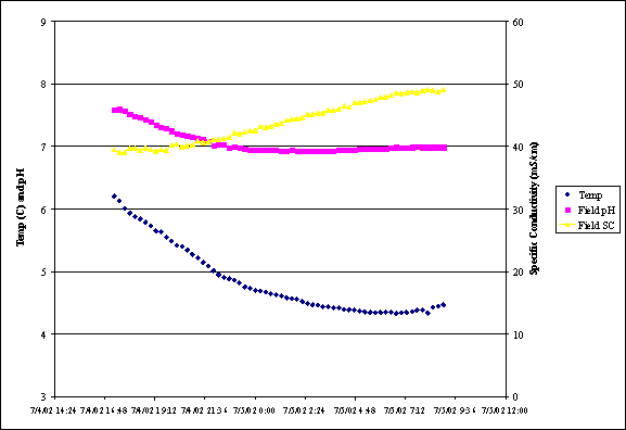
The glacial tributaries sampled showed a surprising variation in chemistry. Some of the channels, though only a few kilometers from their source glaciers, had turbidities as low as 16.8 NTU. Figures 4a and 4b show two creeks each sampled for approximately 15 hours at a 15 minute interval. The fluctuation in chemistries is much greater in the glacial tributary than in the clear water tributary. This is due to variable melting of the glacier causing a continuous change in the proportions of waters sourced from groundwater versus glacial melt. This variability in glacial water chemistry could in part explain why we collected such a wide variety of chemistries from our grab sampling of the 5 major glacial tributaries we stopped at.
As the river brought us downstream there seemed to be an evolution in the chemistries of the tributaries. This pattern (fig 5) indicates that as we traveled downstream the tributaries grew cooler and more dilute. This would indicate that the tributaries in the lower reaches are more snow and ice dominated and less groundwater dominated. A look at the map supports this, as the reaches of the Nizina and Chitina we floated have little glacial coverage when compared to the sections of the Copper we sampled. This evolution in tributary chemistry is mirrored in the changing chemistry of the mainstem. In the Copper River conductivity decreased in the tributaries and the mainstem (though slightly) with distance downstream. Additionally, turbidity decreased in the mainstem of the Copper as the number and volume of clear water tributaries increased. Considering the magnitude of main channel flow when compared to the tributaries, it was surprising to see this correlation in chemical patterns between the main stem and the side channels.
Temperatures of tributaries and the main stem correlated well with proximity to glacial sources. The Chitina with its glacially dominated headwaters had few glacial tributaries on the section we floated, this is reflected in the data as tributary temperatures remain constant (Fig 5) while main stem temperature increase (Fig 1). As we entered the Copper River, proximity to glaciers increased and temperatures in the main stem as well as the tributaries decreased. The thermal buffering capacity of the main stem Copper was evident in the data; with tributary volume increasing and temperature plummeting,
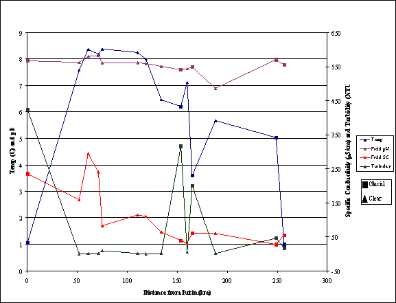
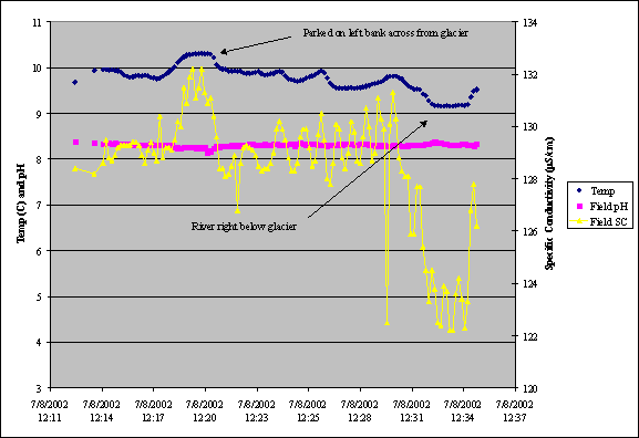
the main stem showed little thermal response, decreasing slightly and then equilibrating. The large volume of water flowing through the main channel was thermally recalcitrant as evidenced in the data collected when floating by Childs glacier (Fig 6). Childs glacier calves directly into the Copper forming numerous icebergs in a reach only 100 meters wide. Visual inspection alone would indicate that the glacier should have a large effect on river temperatures, but the data show that temperature only decreased one degree Celsius as we paddled by and even then only because we moved to river right toward the face of the glacier itself. The corresponding large decrease in conductivity is an indication of how heat transfer and physical mixing are two very different processes, with heat fluxes able to disperse through mixing boundaries accelerating thermal homogenization relative to chemical. It should be noted that 4 miles downstream the temperature of the main stem was 0.4 degrees warmer than above the Childs Glacier; apparently the input from Childs Glacier alone was not enough to alter main stem temperature trends.
Conclusions
The water quality dynamics of the Copper River watershed are controlled by the presence of glaciers on 18% of the landscape (Brabets 1997). The data reported has shown that proximity to heavily glaciated terrain (the upper Chitna and lower Copper) is the driving factor in both tributary and main stem water chemistry. The glaciers add low conductivity, low temperature, sediment rich waters into the system, resetting water quality trends with each major confluence. The nature of this switch in trend gives us insight into the “chemical fingerprint” of each sub-watershed, providing information on the relationships between water, geology, vegetation and land use (the effects of land use and vegetation on water quality will be further discerned when elemental analysis of the samples is preformed). Glacial dynamics have also created the conditions necessary for the formation of gravel bar hyporheic flow channels. Though a fine scale feature in an otherwise expansive context, the waters in these channels have been shown to have a distinct chemistry taken advantage of by numerous aquatic species (see fish report). Taken together, these findings have presented us with a clear picture of how watershed chemistry functions in the Copper River.
REFERENCES
Brabets, T. P., and Alaska. Dept. of Transportation and Public Facilities. 1997. Geomorphology of the lower Copper River, Alaska. U.S. Geological Survey Information Services, Denver, CO.
Edwards, P., M. Tranel, P. Brease, and P. Sousanes. 2000. Stream and river water quality in Denali National Park and Preserve, Alaska. Pages 203-207 in D. L. Kane, editor. Proceedings; AWRA's spring specialty conference; Water resources in extreme environments. AWRA - American Water Resources Association, Bethesda.