General climate and local weather are important driving forces in the Copper River watershed, impacting aquatic and terrestrial life, as well as natural processes [refer to (Bowersox 2002) in this volume for more detail]. To better understand the climate of the glacially influenced Copper River ecosystem, meteorological measurements were collected during the 12 days spent examining the Copper River watershed between McCarthy and Cordova. A Kestrel 3000 Pocket Weather Meter was used to measure air temperature, wind speed, wind chill, relative humidity, heat index, and dew point temperature. The specifications of the Kestrel 3000 are shown in Table 1.
|
Accuracy |
Accuracy |
Minimum |
Maximum |
|
Temperature |
± 1.0 °C |
-29 °C |
70 °C |
|
Relative Humidity |
± 3% |
|
|
|
Wind Speed |
± 3% |
0.3 m/s |
40 m/s |
Unlike a fixed weather station which records all measurements at one location and at regular time intervals, the weather data collected during this study represents a transect down the watershed, starting near the base of the Kennicott Glacier at McCarthy, and ending near the ocean, just outside of Cordova. Measurements were recorded at convenient times during waking hours, with a lack of data collection between the hours of 11 pm and 6 am. Because the data were recorded at irregular time intervals, at different locations, and for such a short time, it is impossible to draw definite conclusions. However, some general observations and assumptions will be discussed below, with the 109 data points summarized by plots.
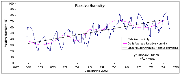
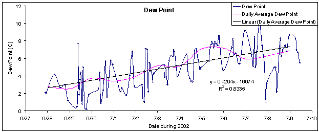
For the entire trip, the weather was uncharacteristically warm and dry. Over the 12 days, the air temperature was expected to decline while transitioning from the relatively dry, warm air of the interior to the cool, moist air along the coast. The recorded air temperature (Figure 1) is in agreement with this expectation. Relative humidity (Figure 2) and dew point (Figure 3) are also in agreement with the expected rise in humidity with increasing proximity to the coast. Glaciers were also in agreement with this trend, with an increasing number observed closer to the coastal moisture supply. Even though humidity increased during the trip, precipitation did not increase correspondingly. The entire trip was surprisingly dry, with rain observed for only eight hours during the 12 day trip. The first recorded rain drop fell at 12:11 am on 7/4/2002, with the rain stopping around 8 am. On the morning of July 4th, snow covered the mountain ridges to the north of camp.
![Figure 1. Air temperature recorded while longitudinally transecting the Copper River watershed from 6/27/2002 to 7/10/2002. Also shown is the daily average air temperature, and linear trend in daily average air temperature. The observed decline in the linear trend is to be expected due to the orographic effect of the Chugach Mountains [refer to (Bowersox 2002) in this volume for more detail].](/sites/g/files/dgvnsk9956/files/media/images/image004_0.gif)
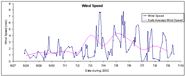
Wind was the most unpleasant weather related factor. Most afternoons and several entire days were quite windy (Figure 4), sometimes slowing the downstream progress of the rafts to a frustrating crawl. Winds were almost always blowing up-canyon, heading inland from the coast. Glacial silt and sand were frequently stirred and carried by the wind, producing a continuous cloud of dust resembling fog. The highest and most sustained winds were observed when the river canyon was the narrowest. Winds were expected, as the Copper River canyon forms the only corridor through the Chugach Mountains, funneling wind from the coast to the interior.
Overall, the data capture the general meteorological climate during the trip. If the collected data were more uniform over the observation period, it is likely that the correlation of the observed linear trends with the daily averages would have been higher. However, even with an incomplete data record, the expected trends are still observed. While heading down the watershed, air temperature steadily decreased, humidity increased, and more glaciers were observed. By sampling the Copper River climate during an unusually warm, dry period, this weather record may not be a fair representation of the typically wet climate of south-central Alaska; however, few of those on the trip will complain about the weather, unless it is a complaint about sunburn.